|
|
Our Purpose Statement:
'To determine the existing quality of Sandy Lick Creek and its
tributaries in order to identify and prioritize areas in need of protection, restoration, and/or further
investigation'
|
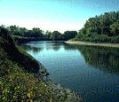
What will the SLCI Members be doing?
Members of the SLCI and other volunteers will be out walking the Sandy Lick Creek and its tributaries.
We will be looking at the condition of the stream.
Each section of stream will be given a 'score' of how
healthy it is. Problem areas, such as: eroding stream banks, drainage from abandoned mines, and excess
nutrients, will be documented.
SLCI members will return to further study these areas and determine what
could be done to correct the problem. SLCI will also return to certain areas to collect water samples.
Once all this information is collected, a plan will be created to prioritize our watershed cleanup efforts.
|
Why is the SLCI doing a Watershed Assessment?
The Sandy Lick Creek is a big watershed. In order to know what is having the greatest
effect on the health of Sandy Creek, SLCI members need to see what is going on in
the stream. Once problems are identified, we can see how much they affect the stream.
Problems can then be prioritized so we know which ones to correct first. The end result
of our efforts will be a report that describes the overall condition of the Sandy Lick Creek
Watershed. The information gained will help to develop restoration strategies.
|
What the Sandy Lick Creek Watershed Assessment is NOT
- The assessment is NOT a regulatory, enforcement, or policing activity.
- The assessment is NOT being conducted to find fault with property owners.
|
The SLCI respects the rights of property owners and wants to establish a positive relationship
with each property owner. We value your opinion and would love to hear from you. Property owners
and interested volunteers are encouraged to send us an email at:
slci@hotmail.com
|
|
The members of the SLCI have established the following schedule for the assessment of the
Sandy Lick Creek Watershed. This is a general schedule and will be adjusted as the assessment
proceeds.
| June 25, 2005 | Visual Stream Assessment Training |
| July 27, 2005 | Public Meeting, DuBois (Upper Watershed) |
| August 2005 | Assessment Meeting - Planning |
| August 2005 | Begin Visual Assessments of Upper Watershed |
| September 2005 | Visual Assessment Training for Volunteers |
| Fall 2005 - Fall 2006 | Visual Assessment Upper Watershed |
| Winter 2005 | Collect Existing Water Data |
| March 2006 | Submit Growing Greener Grant Request for Assessment Funds |
| Spring 2006 | Collect Landowner Information for Lower Watershed |
| June 2006 | Public Meeting (Lower Watershed) |
| Fall 2006 - Fall 2007 | Visual Assessment of Lower Watershed |
| Fall 2007 | Site Specific Water Sampling (as necessary) |
| Winter 2007 | Data Summary, Site Prioritazation |
| Fall 2007 - Fall 2008 | Site Specific Water Sampling (as necessary) |
| Spring 2009 | Complete Site Prioritization and Assessment Report |
|
|
|